A low-pressure system undergoing rapid intensification or “bombogenesis” off the Queensland coast has triggered a severe weather warning for NSW from the Mid-North Coast to the Illawarra.
The system is expected to batter coastal cities including Sydney from Tuesday as a vigorous coastal low brings huge waves, heavy rainfall and gale-force gusts capable of ripping down trees and powerlines.
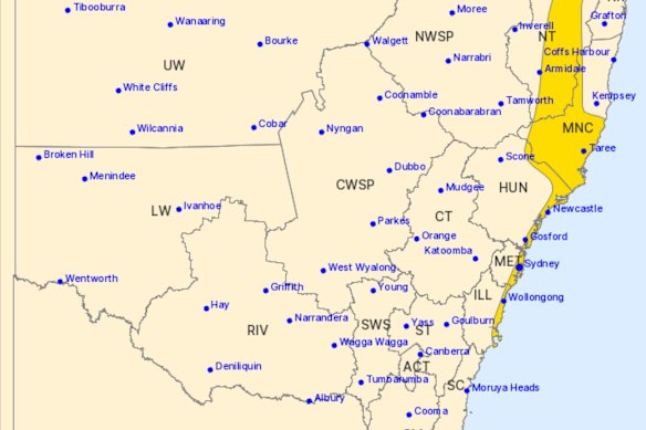
The Bureau of Meterology has issued a severe weather warning for much of the NSW coast.Credit: Bureau of Meteorology
Over the weekend, meteorologists warned that NSW could be in for an east coast low, a severe weather system that once ripped the face off waterfront properties and stole the beach from Collaroy in 2016.
Due to another low developing further out to sea, however, the system is now unlikely to meet the threshold for an east coast low or “bomb cyclone”. The vigorous coastal low will still bring severe winds and rain to the northern coast, the Hunter, Sydney and Wollongong regions over the next 48 hours.
The rapid intensification of the low into a fierce weather system, dubbed “bombogenesis” by meteorologists, is a rare event most often seen during winter.
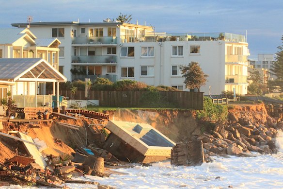
The fallout from an east coast low at Collaroy in 2016.Credit: Peter Rae
“Over the next 24 hours or so, we will see the low form quite deep, quickly, and the central pressure dropping significantly, somewhere in the order of 20 to 30 hectopascals,” the bureau’s Daniel Hayes said.
That plunge in pressure easily meets the threshold for an east coast low. However, Hayes said another low stewing further out to sea will interact with the coastal system, potentially siphoning off energy and reducing the potential for the wide-scale impacts that would define an east coast low.
There’s also a chance the systems could merge into a more powerful low, but forecasting their interaction with any kind of certainty is tricky.
“The two can just dance around each other and both survive but pull energy out each other. Or they could merge, and you eventually get one system.”

Collaroy has been trying to defend its beach using walls in the wake of the 2016 east coast low.Credit: Nick Moir
Unseasonable warmth in the Coral Sea and the Tasman, up to 2.5 degrees above average, is feeding more energy and moisture into the system and contributed to downpours of 50 to 100 millimetres over parts of South East Queensland at the weekend.
Up to 140 millimetres of rain could lash Sydney over the next three days, and there’s a risk to boats and beaches from waves growing to five or six metres.
“Some of that heavier rainfall could lead to riverine flooding,” Hayes said. “There is a flood warning out that covers most of those rivers, from basically the Hawkesbury Nepean south to the Illawarra catchments.
Loading
“We could also see flash flooding away from the rivers themselves, given that there is the likelihood we will see at least some areas of quite heavy rainfall.”
Start the day with a summary of the day’s most important and interesting stories, analysis and insights. Sign up for our Morning Edition newsletter.
Most Viewed in National
Loading