“Councillors, you are being asked to pick up a sledgehammer to crack a walnut … you can reject this recommendation and request staff to prepare a less harmful proposal, and I urge you to do so.”
The Mornington Peninsula council voted last month to put an interim erosion management overlay on about 33,000 properties, in line with a key recommendation from a panel of inquiry into January’s McCrae landslide.
The January 14 landslide destroyed a house at the bottom of an escarpment and forced the residents of 19 other properties to leave their homes for weeks and in some cases months.
Thousands of Mornington Peninsula home owners were told by text message last month that their properties are highly susceptible to landslides and could be subject to new planning controls.
Among them were Louise Aston and husband Tim, who live on a farm in Merricks at the south-eastern edge of the Mornington Peninsula.
The interim erosion overlay had identified a smattering of highly susceptible areas on Aston’s farm, including a small creek and a few dams.
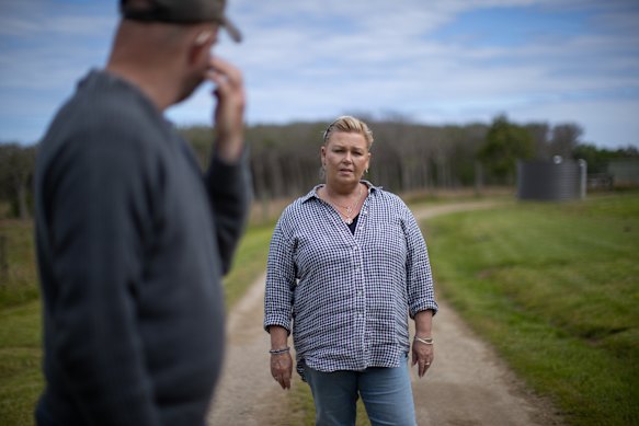
Aston is disappointed with the lack of community consultation around the new erosion management overlay. Credit: Simon Schluter
Aston said the overlay was overkill: “When I got the text I was standing in one of our paddocks, which is flat, looking around, going ‘What landslide?’
Loading
“It’s been done so unprofessionally, with no thought towards the impacts or effects that a little message like that can have on residents.”
The mother of two said she was disappointed with the lack of community engagement and is concerned about the use of outdated maps to identify areas of risk.
The council’s interim overlay is based on data from a 2012 report.
“There needs to be … transparent community consultation with this. There needs to be open meetings held by the council,” she said.
“We have a large elderly population down here, and they’re all panicked about it.”
About seven per cent of land in the Mornington Peninsula Shire was identified in the report as highly susceptible to landslides. This covers about 33,000 properties, 27,000 of which are homes.
The council says that in many cases, a small part of the property would be affected by an erosion management overlay.
Both councils must gain approval from the planning minister before a new overlay can be enforced.
The overlay would compel affected property owners to gain a planning permit and complete a geotechnical report before undertaking renovation or extensions. In some cases – particularly in the Dandenong Ranges, where almost 500 properties have been assessed as vulnerable to debris flow – new development could be ruled out entirely.
Debris flow is rated a more serious risk than landslide, as it involves material including toppling trees flowing rapidly down a slope, putting lives at risk.
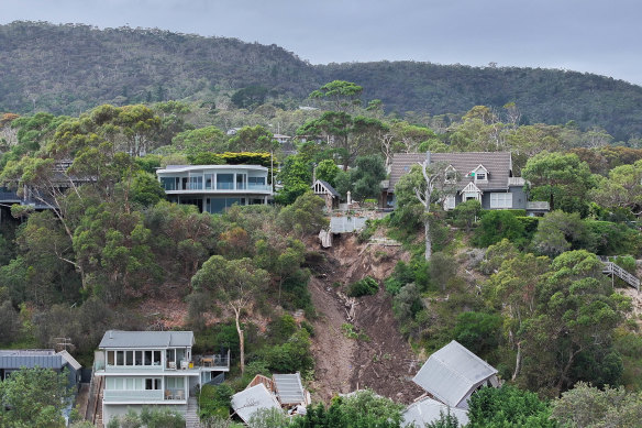
The cliff in McCrae experienced four landslides between November 2022 and January 2025.Credit: Joe Armao
The Yarra Ranges council said in response to 68 objections to its proposed overlay that possible loss of property value or insurance cost increases are not relevant. It also said that landslide risk is likely to worsen as storms become more intense due to climate change.
“Planning panels do not generally consider financial implications, such as property values, when considering planning scheme amendment changes, especially with regard to hazard assessments,” a council report says.
David Kennedy, professor in physical geography at Melbourne University, has studied the Mornington Peninsula coastline for decades and says that many properties have been built in areas that are susceptible to landslides.
The local backlash to the proposed overlay is understandable because of its potential to depress property values and push up insurance costs, Kennedy said. But he said erosion and landslide risks were real and had to be accounted for in planning controls.
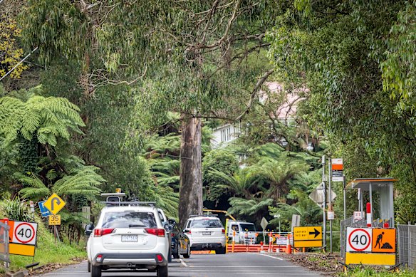
Mount Dandenong Road in Sassafras was reduced to one lane for 11 months after being damaged in a landslide.Credit: Wayne Taylor
“Ignorance is bliss,” Kennedy said. “If you don’t go to the doctor, you don’t get any bad news. But the problem is, eventually there will be bad news, and that’s what we saw at the landslide at McCrae.”
A board of inquiry into the McCrae landslide urged the council to introduce an erosion management overlay to its planning scheme “to at least those areas of the shire that are highly susceptible to landslides”.
The inquiry found the landslide was caused by a burst water main that leaked undetected for months but was also critical of the council’s failure to implement erosion management overlays in landslide-prone areas.