Sydney cops a soaking ahead of storm threat, severe weather warnings issued around the state
After a brief period of glorious summer-like conditions, Sydney is copping a drenching, with severe weather warnings being issued in the state’s south-east.
The city could see as much as 45mm of rain today, as temperatures plunge from 29 degrees on Monday to 19 degrees on Wednesday.

A local braves the rain to get laps in at Bronte’s ocean pool on Wednesday morning.Credit: Steven Siewert
The Bureau of Meteorology is forecasting a possibly severe thunderstorm in the late morning that could bring damaging winds, large hail and heavy rain.
While there are no weather warnings currently in place for Sydney, BoM is urging Sydneysiders to stay alert to the possibility of localised flash flooding on Wednesday afternoon and into the evening.
Wind will also be a factor, shifting from southerly to easterly and finally to westerly throughout the day, with speeds of up to 30km/h forecast through the morning.
Hazardous surf warnings are in place for much of NSW, including Sydney, from the mid north coast to the Illawarra and down to Bateman’s Bay.
NSW Police advises against entering the water or rock fishing, and suggests that boaters change routes or delay plans to cross shallow waters or ocean bars.
The beautiful weather Sydney saw on Monday and Tuesday was always expected to be short-lived. The Bureau of Meteorology’s Jiwon Park explained it was caused by a warm air mass being pushed ahead of an oncoming cold front.
“Ahead of the passage of a cold front, you usually get heat because the winds come northerly and they draw heat from inland Australia,” Park said.
The cold front has now arrived, bringing with it wet and windy conditions and a 10-degree drop in temperature.
Meanwhile, much of the state’s coastal south-east is under a severe weather warning with heavy rainfall bringing the risk of flash flooding on Wednesday afternoon.
Totals of up to 140mm across the day are possible in parts of the Illawarra, northern South Coast and Southern Tablelands, with dumpings of up to 100mm expected within a six-hour period. Major hubs expected to be affected include Wollongong, Nowra, Batemans Bay, Goulburn, Bowral and Braidwood.
The heavy rainfall is being delivered by a complex low that is moving over that part of the state, and will move offshore around Jervis Bay by Thursday morning.
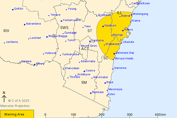
A severe weather warning for heavy rainfall is in place for resident of the Illawarra and parts of South Coast and Southern Tablelands Forecast Districts.Credit: Bureau of Meteorology
NSW SES warns residents to avoid floodwaters, creeks and storm drains. The region also faces unique risks because of bushfire damage, with runoff from rainfall behaving differently in fire-affected areas.
Runoff water can travel more quickly and contain debris, including ash, soil, trees, and rocks. The loss of foliage also heightens the risk of landslides when heavy rain makes the ground soft and heavy.
Start the day with a summary of the day’s most important and interesting stories, analysis and insights. Sign up for our Morning Edition newsletter.
Most Viewed in National
Loading