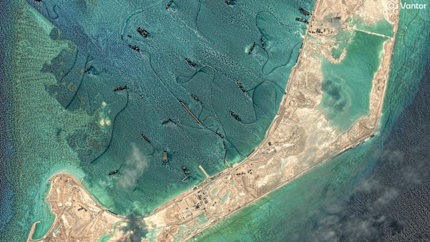
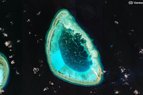
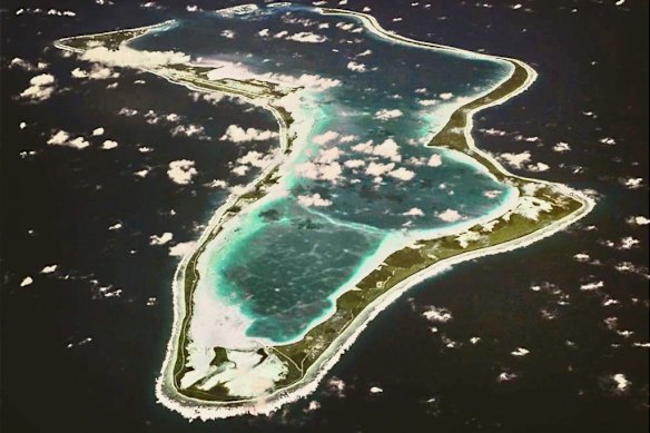
Not so long ago, Antelope Reef was barely on anyone’s radar. The tiny atoll off Vietnam, in the South China Sea, was just one of dozens in this region, home to a handful of Chinese fishermen who lived in huts made ingeniously from shells and lumps of coral.
Much of this picturesque but ultimately desolate place was underwater at high tide. Getting supplies there by boat, across difficult-to-navigate passages, was tricky; there was no airstrip; electricity was limited to generators. Once in a while, a typhoon would rip through: in 2009, 34 fishermen had to be plucked to safety, though the coral huts stood firm.
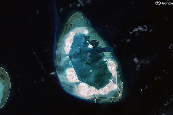
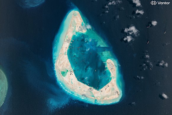
Over the past few months, this tiny outpost has been transformed. In late 2025, China sent in a fleet of dredging ships to suck up sand from the lagoon and pump it on to the existing reef, rapidly increasing the amount of island that poked above water at high tide. By April this year, satellite images showed the atoll had sprouted new jetties, roads and a helipad (which must have astounded the once-marooned fishermen).
Analysts now expect work to begin on an airfield. Given the atoll’s particular horseshoe shape, the potential is for one of the longest, and strategically most useful, air bases in the Paracel Islands, which have long been contested by China, Vietnam and Taiwan. It could even match that of the strip at better-known Mischief Reef, in the nearby Spratly Islands, where China has also been hard at work turning dots on the map into what appear to be military installations.
Elsewhere in the Indo-Pacific – our backyard – India has its own island ambitions, as do various other nations, including the United States, which has come under scrutiny for its secretive base on Diego Garcia, in the middle of the Indian Ocean, which recently made news after it was reported to have come under attack from Iranian missiles.
Why are island strongholds so sought after? Who has what where? And where is our own island continent in the mix?
When did tiny islands become so prized?
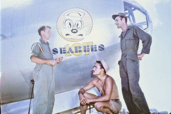
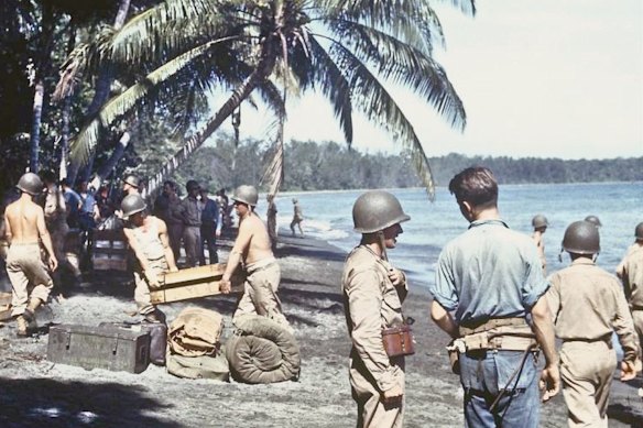
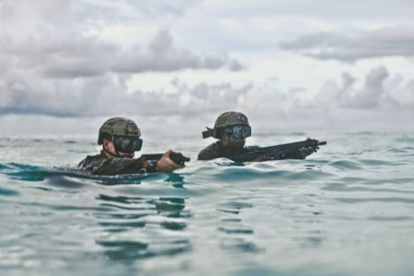
Never were dots in the middle of the ocean more valued, militarily, than during World War II. America’s entry into the war was prompted by Japan bombing its island naval base Pearl Harbour in 1941, after which a new form of warfare emerged: island-hopping. From Hawaii in the east and Australia in the south, US marines, air forces and navy vessels leapfrogged across the South Pacific, engineers from their Construction Battalion, or CB (known as the Seabees), building airstrips, ports, barracks and mess halls almost overnight across the Cook Islands, the Solomons, Fiji, New Caledonia, Tonga, Bora Bora, the New Hebrides (now Vanuatu) and more.
Some islands were already occupied by the Japanese, themselves leapfrogging as far south as Papua New Guinea. Previously unknown islands became household names: Guadalcanal, Wake, Midway and Iwo Jima, all scenes of ferocious battles either on land or in the surrounding waters.
“The Pacific is, and always has been, really important to US national security,” says Kathryn Paik from the Centre for Strategic and International Studies in Washington. “When we look back at World War II, there was a reason why those islands were locations of some of the hardest fought battles.”
After the war, most of the hard-won bases were swiftly decommissioned, their buildings demolished and, at times, weaponry and ammunition dumped into their pristine lagoons. But a handful were deemed still useful. Johnston Atoll, a wartime refuelling stop for submarines and planes, became a launch pad for testing nuclear missiles in the 1960s and, later, was deemed a conveniently remote place to dispose of chemical weapons. It’s now a wildlife refuge that you can visit only with a special permit.
Further east, the airfield at Tinian, in the Northern Mariana Islands – the base for the atomic attacks on Japan in 1945 – is now a civilian airport serving modern-day island-hoppers. Nearby is Guam, seized from the Japanese in 1944, prized not just for its strategic location, within striking distance of Tokyo, but also for its sources of fresh water and plenty of space for runways.
‘There was a sense of, well, New Zealand and Australia have this region, and if anything needs to be done, they’ll take care of it.’
Kathryn Paik, Centre for Strategic and International StudiesMuch of Guam is still occupied by the US military, home base to several nuclear-powered submarines and several thousand troops. Sometimes described as “the westernmost speck of America”, Guam is, technically, one of five permanently inhabited, unincorporated territories of the United States, originally ceded to the US by Spain at the end of the Spanish-American War in 1898. The island’s residents use the US dollar but are ineligible to vote (instead represented in the US House of Representatives by a non-voting delegate).
Not too far away is Kwajalein Atoll, a collection of more than 90 islands and islets in the Marshall Islands, which also hosts a US military base under a relationship called a Compact of Free Association. In more recent times, it has been used for testing missiles and orbital rocket launches. Postwar, it was where inhabitants of nearby Bikini Atoll were eventually relocated to make way for atomic tests.
China’s moves to fund piers and ports in islands such as Vanuatu and the Solomon Islands have rattled observers in recent times, and Australia has either signed, or is seeking to sign, security pacts with island nations such as Tuvalu, Nauru, Tonga, Vanuatu and Fiji. But it is China’s island-development campaign across the South China Sea, and friction between itself and, particularly, Vietnam and the Philippines, that has newly brought strategic island outposts into sharp focus.
“Through the last half of the 20th century, the US took the Pacific region quite a bit for granted,” says Paik, a former US Marine who served as attaché to Indonesia and as a director for South-East Asia and the Pacific Islands on the National Security Council. “There was a sense of, well, New Zealand and Australia have this region, and if anything needs to be done, they’ll take care of it. That has shifted quite significantly as China’s ambitions and their capability to have further reach have increased. That’s really set off alarm bells for the US.”
Where are the South China Sea’s island flashpoints?
Even a tiny rock can be geopolitically significant. “Islands have always played a really important role in strategy,” says Sam Bashfield, a research fellow at La Trobe University’s Centre for Global Security. “Many countries like Australia, the United States and others have their continental mainland, and then they have had a series of islands which have been able to extend the reach of militaries.”
In 1982, the United Nations Convention on the Law of the Sea granted states exclusive rights over marine resources extending 200 nautical miles (370 kilometres) beyond their territorial waters. Japan’s “ritou” (remote) islands, for example, make the nation’s marine area among the biggest in the world, even though Japan itself is the world’s 62nd largest country by land area.
‘Islands in international law are a mixed blessing.’
Andrea Caligiuri and Enrico MilanoUnder maritime law, though, islands are generally defined as masses of land that are above water at all times and are, technically, habitable. “Islands in international law are a mixed blessing,” write Andrea Caligiuri and Enrico Milano in the journal Questions of International Law. “On one hand, they may significantly augment the sovereign and jurisdictional rights of states, in particular over vast amounts of marine space. On the other, they pose complex problems concerning the determination of their [legal] nature.”
Atolls such as those in the South China Sea – formed millions of years ago by volcanoes that then subsided underwater, leaving just a ring of coral reef that grew up around them – are often submerged at high tide and rarely have fresh water, making their status ambiguous. Most contested in recent years have been the Spratlys, an archipelago of more than 100 islands (or might-be islands) roughly midway between the Philippines and Vietnam, and the Paracels, some 130 reefs, shoals, islets and sandbanks further north.
China had a minimal presence across the Spratlys and Paracels from the 1950s, but ramped up its claims from 1988 onwards, when it clashed with Vietnam over ownership of Johnson South Reef in the Spratlys, seized it (killing some 67 Vietnamese personnel) and subsequently occupied a half-dozen or so islets and shoals nearby. What it wanted with these chunks of coral was revealed from 2014. That’s when satellite images showed that China had brought in civil engineers to turn Johnson South Reef into a substantial military base, part of a vast project across dozens of islets that naturally became known as the Great Wall of Sand.
‘Australia and the United States and other countries have consistently sailed ships through there, underlining the point that they have a clear right of passage under international law.’
Ross Babbage, CEO Strategic Forum Ltd“Several of these were actually just reefs, and were just marked on charts as reefs, not as places that qualified as an island because they didn’t have land at high tide,” says Ross Babbage, chief executive of not-for-profit Strategic Forum Ltd, who led branches in Australia’s Defence Department responsible for ANZUS policy and force development. “That’s why Australia and the United States and other countries have consistently sailed ships through there, underlining the point that they have a clear right of passage under international law.”
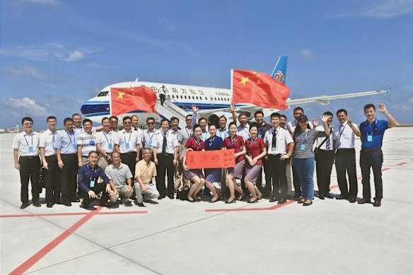
Within just a few years, China created some 1200 hectares (about 3000 acres) of surface area by dredging sand up onto the coral then building sea walls, deep-water channels and, on at least three of these islands, concrete runways. In 2013, photographs showed Mischief Reef was little more than a shallowly submerged coral platform, China’s garrison there mostly living in three octagonal huts on stilts; by 2016, it had been developed enough to allow a China Southern Airlines commercial jetliner to land.
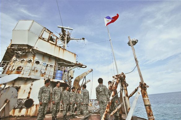
Clashes and near-misses, particularly with the Philippines, are not uncommon. In 2025, the Philippines even alleged China had deliberately put cyanide into the ocean around a ship called the Sierre Madre, a rusting hulk that had been deliberately grounded to house a garrison of Philippines marines. The poison was “a form of sabotage that seeks to kill local fish populations, depriving navy personnel of a vital food source”, a Philippine spokesperson told reporters. China said the claims were a “farce”.
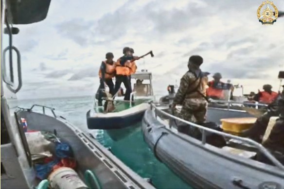
“It’s definitely a possible flashpoint,” says Kathryn Paik, “especially when we look at the Philippines, the US-Philippine Alliance, what is involved there, you know, the questions around if China were to attack a Philippine vessel and kill a Filipino crew member.” In 2024, a Filipino sailor lost a thumb after Chinese coastguards armed with knives and an axe rammed a vessel resupplying the Sierra Madre. A hand-to-hand fracas then reportedly ensued.
On Antelope Reef, meanwhile, works have been well under way, notes Open Source Centre, a UK-based non-profit focused on security issues. “High-resolution radar and optical imagery suggest that this modest start has since expanded into a massive industrial campaign. By early February, the fleet had swelled with 22 ‘cutter section’ dredgers grinding the seafloor and pumping a slurry of rock and sand through floating pipelines.” The Asia Maritime Transparency Initiative, which tracks development in the region, estimated the facility could accommodate a 2500-metre runway, long enough to land fighter jets.
In 2016, the Philippines challenged China’s claims of historic rights to the Spratlys in an international arbitration court, which ruled that China’s claim had no legal basis (the ruling did not directly consider the Paracels).
“They were getting some pushback,” Paik tells us. “They’re a bit sensitive to that, so they took some different approaches over the years. While they may have changed tactics over time, their overall strategy has not changed: they are looking to, essentially, redefine international norms in this space, in a way that advantages China from both a security and an economic standpoint. I like to say they’re shifting the goalposts slowly and normalising both their activity and also their presence in certain areas, in a way when the US doesn’t or can’t respond. And then other countries in the region either look the other way or in, for instance, the Philippine case, might only be able to respond in a minimal way. Or others, like Australia and Japan, may verbally respond but not actually be able to push back significantly.”
For its part, Vietnam has created 2200 acres (890 hectares) of land across some 21 islets that it claims in the Spratlys, several of which also have runways, ports and harbours.
What’s the deal with Diego Garcia and the Chagossians?
On March 20, when Iran reportedly fired two ballistic missiles nearly 4000 kilometres south-east towards the island of Diego Garcia, many wondered, where? And, why? The reason, observers suggested, was to demonstrate the reach of Iran’s rockets – if they could hit Diego Garcia, they could possibly reach Paris or London. The unsuccessful attack, which Iran denied, raised the stakes for the remote island, some 3000 kilometres to the right of Africa and 3000 kilometres to the left of Indonesia, which has been home to a secretive military base and airfield jointly operated by Britain and the US since the early 1970s.
Visiting is virtually impossible, at least for civilians, says Sam Bashfield, who has a book coming out shortly about the island base. “I mean, the only way to do it is to be invited by the US or British military. There have been very limited journalist trips that have taken place there. But, yeah, it’s pretty much off limits.”
‘The Brits and the Americans did a range of surveys ... to look at islands that were going to be decolonised with an eye to which ones should be retained and which ones had military value.’
Sam Bashfield, La Trobe University Centre for Global SecurityPlanes that have had to stop for emergency refuelling have been swiftly filled up and sent on their way. It’s also politically sensitive. A BBC reporter who made a rare visit in 2024 to cover a legal dispute said she was even restricted from detailing what restrictions she was placed under (though she could report the base had a cinema, a bowling alley, a fast-food outlet called Jake’s Place and a British-themed nightspot called Brit Club).
Another source of sensitivity is how Britain came to have Diego Garcia in the first place. It’s part of the Chagos chain, once home to the indigenous Chagossians, descended from slaves shipped to the island by the French in the late 1700s. (Access to other islands in the chain is also restricted, but temporary permission is usually granted to, say, yachties passing through, Ross Babbage tells us.)
“Back in the 1960s,” says Sam Bashfield, “as Britain was decolonising its empire and as the United States’ strength was growing, the Brits and the Americans did a range of surveys around the world, but especially in the Indian Ocean, to look at islands that were going to be decolonised with an eye to which ones should be retained and which ones had military value.”
In 1965, with Mauritius, nominally the owner of the Chagos isles, on the cusp of independence, Britain swiftly hived them off for use as potential military bases, creating what it called the British Indian Ocean Territory. As part of that, it made a formal deal with its ally the US to jointly run a base at Diego Garcia, the largest of the Chagos Islands. Crucially, that treaty said that the UK would retain sovereignty over the islands unless the US agreed to change the arrangement.
“They had this special relationship with the US that enabled them to do these kinds of deals,” Bashfield says. “You’ve got Africa to the west, the Middle East to the North, South Asia to the northeast. It’s just that perfect location. There’s a huge protective anchorage there, space to put a runway in.”
‘The US and the UK recognised at the time that local populations around military facilities can be “problematic” and that they’d much rather have these islands without potential protesters.’
Sam Bashfield, La Trobe UniversityBritain then decided it would be easiest to simply expel the Chagossians. Says Bashfield: “The United States and the UK recognised at the time that local populations around military facilities can be ‘problematic’ and that they’d much rather have these islands without potential protesters. They just thought, let’s just do a clean sweep and just be done with it.” A British Foreign Office memo from the time stated that the plan “was to get some rocks which will remain ours; there will be no indigenous population except seagulls”.
The plan was carried out ruthlessly. Some Chagossians who were overseas at the time were simply refused the right of return. Others were bundled into boats with only what they could carry. Some had their pets gassed. Most were expelled to Mauritius and the Seychelles. Some ended up in Britain, where a community of beleaguered souls gathered in a gloomy suburb of London near Gatwick Airport.
Some have long campaigned to be allowed to return to their homeland. Mauritius has also campaigned to be given sovereignty of the Chagos group, arguing that Britain had taken the islands illegally. After years of negotiations, by February this year Britain was ready to transfer sovereignty to Mauritius, in a deal that guaranteed London a 99-year lease over Diego Garcia. It was complicated. Some Chagossians wanted Britain to retain sovereignty over the islands while the question of their self-determination was settled. Some argued that they had not been adequately consulted in the drafting of the new treaty. “The deal is clearly good for Mauritius, and soothes a diplomatic irritant for Britain,” said The Economist. “But it doesn’t much help the Chagossians.”
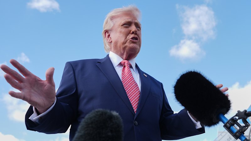
Donald Trump … posted on social media: ‘DO NOT GIVE AWAY DIEGO GARCIA!’
In the event, with war with Iran looming, Donald Trump intervened, saying that Diego Garcia could be necessary as a base for air strikes (it can house B2 stealth bombers and was used for raids in both Gulf wars), posting on social media: “DO NOT GIVE AWAY DIEGO GARCIA!” With US approval required under the original joint-base agreement, the deal has been shelved, at least for now.
Who else has islands in the Indo-Pacific?
India has its own network of islands. In 2019, it established the Kohassa naval air station on North Andaman Island, not far from the Malacca Strait, a shipping choke point. It has also earmarked nearby Great Nicobar Island as a “strategic maritime and economic hub”, with plans for a new port, airport and townships that it says will not adversely affect the island’s indigenous Shompen and Nicobarese people. India also has a presence in the Lakshadweep Islands, an archipelago of 36 coral islands some 220 kilometres off Kerala in the Arabian Sea and, further afield, radar facilities on Assumption Island in the Seychelles, hosted under a partnership between the two nations.
“There’s been a big push recently for what’s called maritime domain awareness,” says Sam Bashfield, “understanding what’s taking place on the surface of the sea and below the sea and also in the air above the sea because the sea is really seen as a spectre of incoming threats, whether that be military, whether that be drug smuggling or people smuggling, illegal fishing, for example, or pollution.”
France’s influence in the region lingers, too, in Reunion island, an ink splat in the ocean to the west of Mauritius that’s an ‘overseas department’ of France.
India has also recently expanded an airbase on the Mauritian island of Agalega, another partnership, with a runway long enough to house long-range commercial and military reconnaissance aircraft. Air Mauritius made a historic first landing there in 2024, the aircraft’s pilot describing his feelings of “national pride” at reaching the milestone. Says Bashfield: “Essentially, they struck a deal to help Mauritius to develop this island, funding these quite large upgrades to the air facilities and also the anchorage there. The controversy comes where these projects are pitched as assisting the local inhabitants, yet you know there’s only 200 or 300 people resident. Constructing three-kilometre runways with huge air-traffic control doesn’t really match the demand on the ground. There’s just a lot of reluctance from both sides, especially Mauritius, to really acknowledge that.”
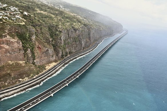
Agalega, actually two tiny islands separated by a 200-metre channel, was once a slave plantation colony; its only town is Vingt-Cinq, meaning 25 in French, a reference to the number of lashes unfortunate slaves would receive. France’s influence in the region lingers, too, in Reunion island, an ink splat in the ocean to the west of Mauritius that’s an “overseas department” of France. “The same as, you know, Paris or as Marseille,” says Bashfield. “They have the same voting rights and have seats in parliament. They use the euro, all the restaurants and the signage is exactly as you see in France.” Reunion is home to a large military presence – and one of the world’s most expensive road projects, a spectacular offshore viaduct called the Nouvelle Route du Littoral. In the Pacific, meanwhile, France has bases in Tahiti (the largest island in French Polynesia) and New Caledonia.
Historically, Australia’s islands have been part of its defence: WWII gun emplacements on Bribie Island off Queensland, for example, and on Rottnest Island off Perth. Norfolk Island was a key refuelling hub for the Allies in the Pacific. Today, Garden Island, a handkerchief of limestone just south of Perth, hosts the nation’s largest naval base (as well as tamar wallabies and carpet pythons); and, of course, there’s a naval dockyard at Sydney Harbour’s Garden Island. Swan Island, in Queenscliff, Victoria, has the odd privilege of accommodating both top-secret training facilities for the SAS and, famously, a public golf course, accessed through a military checkpoint.
Offshore, two particular island groups are critical to extending Australia’s reach into the Indian Ocean. The double-barrelled Cocos (Keeling) Islands, 2750 kilometres northwest of Perth, are so called both for British East India Company sea captain William Keeling, who sailed by them in 1609, and also for the coconut plantations on the atoll run for 150 years by the Scottish Clunies-Ross family. The island became an Australian territory in 1955, but it was not until 1984 that its people voted in a UN-administered referendum to integrate with Australia. Christmas Island, about 1500 kilometres from Australia, was transferred to Australia from Singaporean authority in 1958.
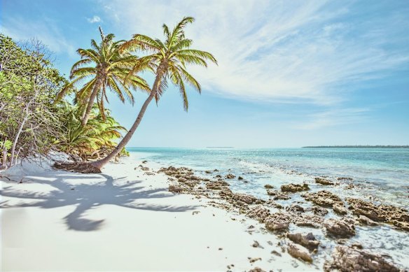
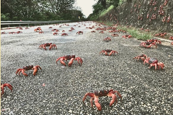
Geographically, they are quite different. Christmas – famous for its spectacular red-crab migrations, when millions march to the ocean to spawn – is singular, the tip of an ancient underwater volcano that rises 360 metres above the sea (think Tom Hanks in Castaway), known for its spectacular cliffs, caves and blowholes. At the 2021 census, it had a population of about 1700.
The Cocos (Keeling) Islands form the perimeter of a horseshoe-shaped atoll, 27 islands and islets ranging from tiny to slightly less tiny, clustered around a pair of sapphire-blue lagoons, the highest dry land just five metres above sea level (which is rising). Some 600 people inhabit two of the islands: Home and West, popular with travellers who appreciate their largely unspoiled beauty (one beach here was declared Australia’s best in 2016) and who are not fussed with luxury resorts. “You’ll find most things you need for your stay,” suggests a guide to the supermarket on the Cocos’ West Island, “but please note that fresh produce is limited given our super-remote location.” (It’s flown in fortnightly.) Opening hours at the handful of restaurants and cafes can be flexible, some dependent on whether there’s a plane or ferry scheduled.
On Christmas Island, meanwhile, the popular pub Tracks Tavern, which hosted two-up on Anzac Day, is for sale, if you fancy a change of pace. Visitors hoping to reach either island group should be aware that flights are heavily weather dependent and sometimes baggage has to be left behind due to weight restrictions, according to Sam Bashfield, who visited both last year.
Strategically, the port at Christmas Island is the gnarlier of the two – weather dependent, where ships moored offshore are exposed to ocean swells. The Port of Cocos is protected, within a lagoon. The airfield at Cocos is getting an upgrade, says Bashfield, so larger surveillance aircraft can land there – “sensitive maritime patrol aircraft that have a whole range of functions, but keeping tabs on submarines is probably their most important”.
Google, meanwhile, has built a “connectivity hub” on Christmas Island, which is a vital stepping-stone for underwater cables linking the Australian mainland with Singapore. (Google has refuted recent reports that it was building an artificial intelligence data centre there.) Both islands are “very important” to Australia, says Ross Babbage, who has also spent time on them. “Could they be used more extensively in a crisis? Yes, absolutely.”
Get fascinating insights and explanations on the world’s most perplexing topics. Sign up for our weekly Explainer newsletter.