Over the weekend, the bureau warned NSW could be in for an east coast low, which refers to a severe weather system that dumps dangerous amounts of rain and inflicts widespread damage.
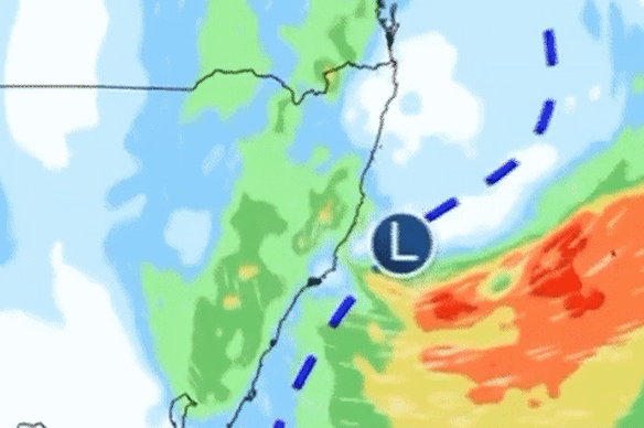
A powerful east coast low was forecast over the weekend.Credit: Bureau of Meteorology
BoM meteorologist Jiwon Park says the current complex low-pressure system probably qualifies as a low-end east coast low, but that doesn’t necessarily warrant the term being used.
“We reserve the term ‘east coast low’ for the really high-end event that brings widespread major level flooding, and broad areas of destructive wind gusts.”
The bureau has called the system a vigorous coastal low instead.
But that shouldn’t be seen as a downgrade, said Steve Turton, an adjunct professor of environmental geography at CQUniversity. He echoed warnings from the SES and the bureau that effects will be short, sharp, intense and unpredictable.
“Off-shore, the winds will certainly be storm-force, which is like a category two tropical cyclone in intensity,” he said.
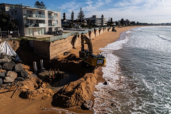
Collaroy has been trying to defend its beach using walls in the wake of the 2016 east coast low.Credit: Nick Moir
“That’s certainly going to increase the wave energy and the swells and so on coming onto the coast. We’re looking at over 5 million people likely to be affected by this system.”
The silver lining is that the low will move faster than a classic east coast low, limiting the amount of rain that will pelt the coast and lowering risk of major flooding.
Abnormally warm water off the NSW coast helped fuel the system’s rapid intensification, Turton said. Warmer oceans turbocharge the energy of a storm and supply weather systems with more moisture for heavy rain.
A region of ocean water brewing 1 to 2.5 degrees above average also contributed to Tropical Cyclone Alfred and May’s flood disaster, Turton said.
“That pool of warm water off the coast will certainly be providing additional energy into this system and increases the risk for more rapid intensification and flash flooding,” he said.
About 90 per cent of the Earth’s extra heat cause by the burning of fossil fuels is trapped within the ocean, he noted.
NSW east coast weather warnings
A severe weather warning for damaging, locally destructive winds is in place for Sydney, the Illawarra, and parts of Mid North Coast, Hunter, South Coast, Central Tablelands, Southern Tablelands, Northern Tablelands and Northern Rivers.
A hazardous surf warning was issued for the coast from the Hunter down to Eden, with rock fishers, boaters and swimmers urged to stay away from the ocean.
Coastal erosion and damage to infrastructure may strike the coastline between Seal Rocks and the NSW-Victorian border.
A flood watch for minor flooding is in place for southern parts of the Mid North Coast, the Hunter, Hawkesbury-Nepean, Sydney-Illawarra Coast and Snowy catchments.
NSW SES is advising residents along Sydney’s coast, from Collaroy in the north all the way to Wollongong in the south, to stay indoors.
Stay up to date with warnings here or on the Hazards Near Me app.
Flight cancellations
Virgin is advising guests travelling in and out of Sydney and Newcastle that their flights may be affected by the wild weather, while a Qantas spokesperson says it anticipates more cancellations in and out of Sydney later today.
Twelve Virgin and seven Qantas flights have been cancelled so far today.
“We encourage guests travelling today and tomorrow to keep an eye on the status of their flight via our website or app,” a Virgin spokesperson said in a statement.
Public transport
Transport for NSW has issued a weather alert asking commuters to take care while travelling.
Wild weather may coincide with the trip home tonight as passengers face a tough trip home compared to this morning’s smooth-sailing.
Start the day with a summary of the day’s most important and interesting stories, analysis and insights. Sign up for our Morning Edition newsletter.