The extraordinary storm cell over the Great Ocean Road that washed away cars on Thursday was powered by a rare collusion of five weather drivers – and is a taste of the increasing extreme weather the climate crisis is unleashing on Victoria.
Sudden, dramatic downpours struck towns across the Otways on Thursday, flooding campgrounds, triggering evacuations and sweeping cars out to sea. Police winched a man from the growing muck.
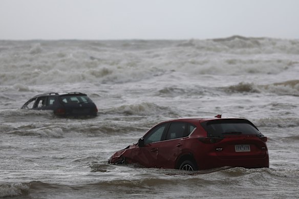
An unusual set of meteorological circumstances conspired to cause Thursday’s deluge at Wye River.Credit: Alex Coppel
The Bureau of Meteorology’s weather gauges recorded more than 170 millimetres of rain in just seven hours near Mount Cowley, the storm’s epicentre – a record.
Extreme thunderstorms with heavy rainfall are often seen in tropical Queensland, but are – or were – rare in colder Victoria.
As the world warms, “extreme weather events tend to get more extreme”, said Angus Hines, senior meteorologist at the Bureau of Meteorology. “Those very rare, very damaging weather events … all of a sudden start looking more common.”
What happened on Thursday to trigger this?
Five drivers collided to produce the downpour.
First, ex-Tropical Cyclone Koji. It crossed the Queensland coast on January 11 near Bowen, bringing strong winds and heavy rainfall.
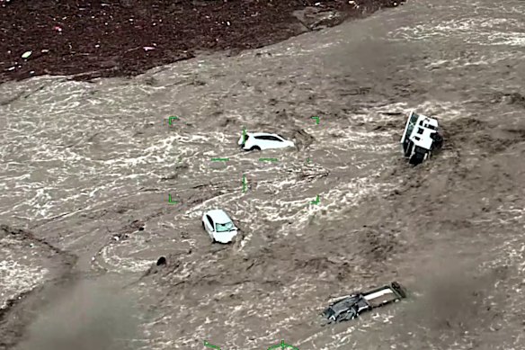
Stills from footage of the Air Wing’s rescue response following flash flooding along the Great Ocean Road on January 15.Credit: Victoria Police
The cyclone had a long tail of heavy moisture, a band of thick clouds that ran down through NSW and curled around Victoria’s southern coast.
This moisture “primed” the atmosphere across the state for heavy rainfall, said Hines.
Then came the thunderstorms.
Scenes from the flood at Wye River.Credit: Alex Coppel/Nine
At 12.40pm on Thursday, the Bureau of Meteorology issued a severe thunderstorm warning covering the Otways and east into Gippsland.
Thunderstorms are hard to predict accurately. Meteorologists prefer to give ranges and acknowledge that there will be pockets of intensity within that range. “It’s just the nature of thunderstorm outbreaks,” said Hines. On Thursday, a strong storm developed over the ocean south of Lorne.
Strong winds from the south-east pushed the storm onshore, dumping rain over the Great Ocean Road.
It was what happened next that turned thunderstorm into disaster.
Inland of Lorne lie the low coastal mountains of the Otway Ranges, topped by 689-metre Mount Cowley. The strong winds pushed the thunderstorm into, up and over the mountain range.
When air moves upwards, it cools. This encourages water vapour trapped in the air to condense into raindrops – known as orographic precipitation.
While that was happening a few hundred metres above sea level, a different but complementary process was playing out high in the atmosphere, where a low-pressure trough had formed.
Low-pressure troughs encourage air from lower in the atmosphere to flow up – where it cools, and water vapour turns into raindrops. “That’s really what drives the formation of showers and thunderstorms,” said Hines.
The atmosphere had been primed by ex-Tropical Cyclone Koji. A thunderstorm formed across the coast, and then was pushed inland by strong winds. From below, mountains squeezed out extra rainfall, and from above a low-pressure trough triggered more precipitation.
“It’s a tropical event. In Victoria, we’re not really used to that intensity of rain,” said Andrew King, an associate professor in climate science at the University of Melbourne.
To this, we need to add one last non-weather driver: drought. Over the last four years, the Otways have experienced unusually low levels of rainfall. Much of south-west Victoria is struggling through some of the worst drought conditions on record.
Counter-intuitively, dry soil tends to struggle more than moist soil to absorb rainfall. Water pools on the surface and runs off.
“Because you haven’t had much rain down there, it’s been extremely dry, it does not soak in. The runoff is tremendous. It goes in and just washes dirt. You can see all the mud,” said Dr Milton Speer, a meteorologist and visiting fellow at the University of Technology Sydney.
Is this event linked to the climate crisis?
Australia has already warmed by more than 1.5 degrees since records began in 1910 – the limit set by the Paris Agreement.
But the contribution of the climate crisis to Thursday’s flash flooding, and to rainfall in Australia, is complex.
In general, warmer air is able to hold more moisture. “And elevated moisture in the atmosphere was a crucial part of yesterday’s rainfall,” said Hines. “The weather pattern we saw yesterday in Victoria wouldn’t have been out of the ordinary in some parts of tropical Queensland.”
That means more, and more intense, heavy rainfall events and associated flash flooding across the world – including in Australia. Rain associated with tropical cyclones, like Koji, is also increasing.
“When you have the right weather and right meteorological conditions in place, you can get more rain than you would get pre the climate crisis, because the air is warmer and can hold more water,” said King. “This is kind of the expectation.”
However, our warming world is predicted to decrease the amount of rainfall across Australia’s southern coast.
Hence, it is not straightforward to say Thursday’s events were directly caused by the climate crisis, said King.
“There will be a climate crisis component to this, but it’s hard to say how big it is, and it’s probably not actually that big.”
Get to the heart of what’s happening with climate change and the environment. Sign up for our fortnightly Environment newsletter.
Most Viewed in Environment
Loading