‘Rainfall won’t end there’: Deluge drowns Queensland’s north, with warning of 700mm
Residents in Far North Queensland are bracing for a possible 700mm rainfall deluge, after parts of the region were drenched by more than 300mm in the past 24 hours.
With heavy monsoon rain and widespread flooding expected across the region this week, warnings were in place over risks to lives and property damage.
Some communities could be impacted over a prolonged period.
“On Sunday and into Monday morning, we did see widespread showers and thunderstorms right across northern Queensland, but the heaviest of the rainfall was about the north-east tropical coast and also the gulf country and north-west of the state,” Bureau of Meteorology forecaster Jonathan How said.
In the past 24 hours, 320mm of rain fell at South Mission Beach, of which 196mm was recorded in six hours. At Oakland Park, to the south-east of Normanton, 226mm fell in the past 24 hours.
Residents of Innisfail and Ingham copped between 100mm and 200mm of rain, while residents in Normanton had 90mm.
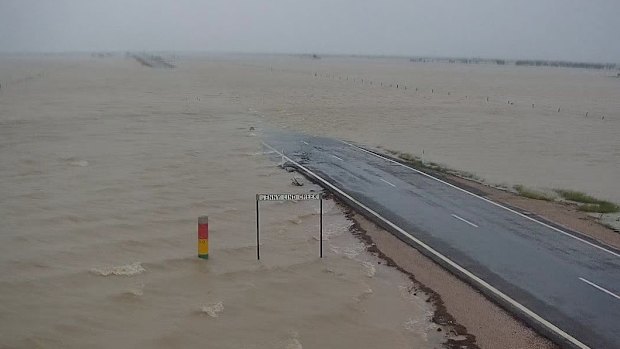
Flooding at Jenny Lind Creek, captured on the Carpentaria Shire Council’s camera.Credit: Carpentaria Shire Council
“Heavy rainfall will lead to road closures and community isolation, and this could last for quite some period of time, especially for outback and more remote communities,” How said.
The weather bureau was expecting the rain total leading in to Wednesday to reach up to 700mm.
“Rainfall won’t end there, we are expecting that monsoon low and trough to continue moving across eastern parts of Queensland but we’ll have a better idea of where rainfall is expected … through the second half of this week.”
A major flood warning for the Flinders River and moderate flood warnings for the Cloncurry River and Western River were in place.

Little Bynoe River is seen flooded on the Carpentaria Shire Council’s camera.Credit: Carpentaria Shire Council
Townsville and Cairns were expected to escape the worst of the weather.
“In the north-east, we could see six-hourly rainfall totals of between 120mm to 200mm, bringing flash flooding, and in the north-west of the state, we could see the six-hourly rain for totals of between 75mm to 120mm,” How said.
Separate severe thunderstorm warnings might also be issued, with the possibility of 180mm to 260mm in a six-hourly period, which could produce life-threatening flash flooding.
Sandbagging stations have opened in the Mount Isa and Hinchinbrook areas, with locals urged to take precautions.
Hinchinbrook, a popular tourist destination, remained in the firing line, and mayor Ramon Jayo said the worst was expected from Monday.
“Despite the extensive rain experienced ... river levels remain below minor and modelling suggests that the most likely scenario is that some will remain about such level into Monday morning at this stage,” Jayo posted to social media.
“However, it is critical to understand that this circumstance may change rapidly, dependent upon where the convergence settles and [what] rainfall is experienced and this situation will be monitored closely.”
Residents in low-lying areas have been urged to protect their property if drainage systems struggle to clear water in torrential downpours.
With AAP
Start the day with a summary of the day’s most important and interesting stories, analysis and insights. Sign up for our Morning Edition newsletter.
Most Viewed in National
Loading