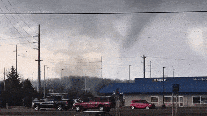
Residents in south-east Queensland have once again been warned to expect severe storms on Thursday evening, but the latest tempest was predicted to be more isolated than the wild weather that lashed the region earlier this week.
The new threat comes after three days of afternoon and overnight storms, as well as severe heatwave conditions, with the devastation prompting Disaster Recovery Minister Ann Leahy to ask the federal government to declare a disaster to trigger national assistance.
Severe thunderstorms are possible on Thursday afternoon and evening from Cairns all the way down the coast into north-east NSW, meteorologist Dean Narramore said.
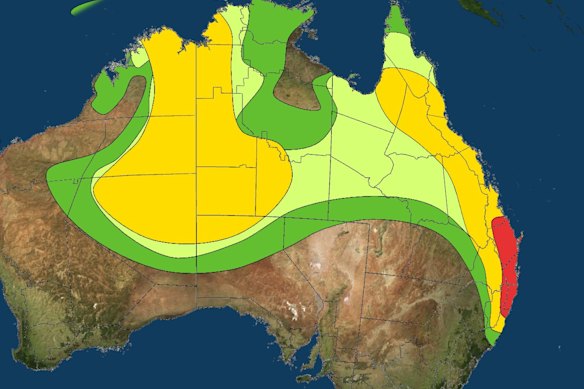
The Bureau of Meteorology has forecast more isolated severe storms in south-east Queensland.Credit: Bureau of Meteorology
The storms could include large hail, damaging winds and heavy rainfall, with the coast between Bundaberg and Byron Bay expected to bear the brunt.
“That’s where severe thunderstorms are likely today, containing large hail, damaging winds and heavy rainfall,” Narramore said on Thursday. “Some of these storms could bring destructive winds and giant hail.
“Not everyone in this area will be experiencing severe storms today, but those that do are likely to see some pretty severe storms this afternoon, into the early evening.”
The storm over Brisbane’s CBD on Monday.Credit: Cameron Atfield
Narramore said the hail could be big enough to cause damage to property, vehicle and crops.
“You do not want to be outside in that,” he said. “So please move your cars undercover and stay inside when the storm approaches.”
Loading
The storms may also be severe enough to bring down more powerlines and damage properties, but they are expected to be more isolated through far north-east NSW and south-east Queensland than those earlier this week, Narramore said.
“They’re likely to be intense ... with widespread severe storms further north,” he said.
“As we get into the evening hours, storms quickly disappear as they lose the heating of the day. But with severe storms forecast, impacts once again are going to be on the high end, like we’ve seen over the past few days.”
The storm systems further north in areas such as Wide Bay and Capricornia may become slow-moving, which could introduce a heavy rainfall threat that might lead to flash and localised riverine flooding, Narramore said.
While Brisbane’s heatwave conditions persisted on Thursday – peaking at 36 degrees with a “feels like” temperature of 39 – Narramore said Friday would “give us all a break to clean up and recover”.
He said Friday would be a “much calmer and clearer day in south-east Queensland”.
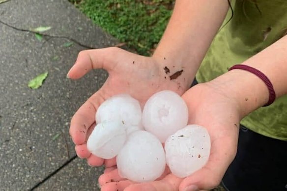
Golf-ball-size hail fell at The Gap on Monday, with more to come.Credit: Angus White
The respite will be short-lived however, with a large rain band forecast to approach the coast on Saturday afternoon and evening, bringing more thunderstorms to much of eastern and south-eastern Queensland and far north-eastern NSW.
“Some of them could be severe with heavy rain, large hail and damaging winds,” Narramore said.
More than 13,000 homes in south-east Queensland remain without power after Wednesday night’s storm brought more than 1.67 million lightning strikes. An additional 9500 homes lost power across the region.
Start the day with a summary of the day’s most important and interesting stories, analysis and insights. Sign up for our Morning Edition newsletter.
Most Viewed in National
Loading