More than 32,000 homes in another two Melbourne council areas are at risk of flooding from overflowing drains, according to new maps released by the city’s water authority.
About 23,030 properties in the Glen Eira council area – which includes Elsternwick, Caulfield and Bentleigh in the south-east – and 9580 under Merri-bek council – such as Brunswick, Coburg and Pascoe Vale in the inner north – would be at risk if a severe flood were to hit those suburbs today.
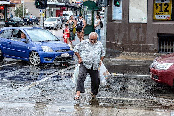
Flash flooding on Sydney Road, Brunswick, in 2017.Credit: Justin McManus
Melbourne Water is updating its flood modelling for each municipality around the city over the next two years.
Earlier this month, more than 60,000 properties in the Darebin and Yarra council areas were deemed at risk, prompting frustrated residents to demand funding to manage the escalating threat of flooding as Melbourne’s ageing stormwater system struggles to cope with intensifying rain.
The water authority and the state government have rolled out a new risk-based flood rating system that ascribes a lower or higher threat level to homes, mirroring the approach used in bushfire-prone areas.
Almost 80 per cent of at-risk properties in Glen Eira and 70 per cent in Merri-bek are in the lowest two categories, out of a total six, meaning water could reach depths of 50 centimetres. Melbourne Water expects this to be below the floor level of many homes.
Interactive maps are on Melbourne Water’s website, allowing people to enter their address and view their risk rating today and in the future with worsening climate conditions.
Only stormwater flood maps are so far available. Waterway modelling is still under way.
Glen Eira’s modelling includes stormwater drains managed by Melbourne Water and the council. Merri-bek’s mapping only accounts for Melbourne Water’s system because the local council recently completed its own analysis of its assets, finding 6503 properties were at risk.
Across the city, about 1500 kilometres of stormwater drains are managed by Melbourne Water and 25,000 kilometres belong to councils.
Before the Darebin and Yarra risk-rating system was unveiled, a blanket inundation overlay would be placed over properties regardless of their level of risk, foisting insurance cost rises, decreased house values and tough building restrictions onto home owners.
The state government hopes its new flood zone controls will help alleviate some costs for home owners if their property is classed as low risk. Its aim is also to equip developers with better information on how and where to build.
Loading
Residents have been critical of the new modelling, arguing the new hazard ratings are of little use without a clear strategy for tackling flood risk and funding mitigation works.
Yarra councillor Kenneth Gomez will move a motion at Tuesday night’s council meeting calling on Melbourne Water to publish the methodology for its maps and extend the eight-week consultation period.
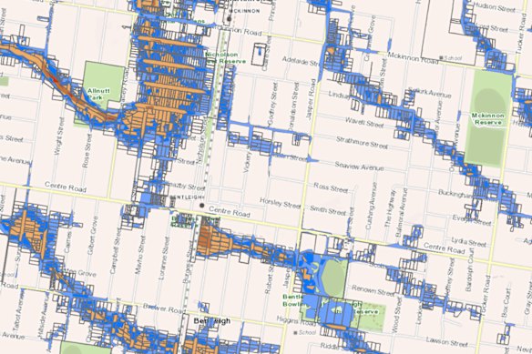
An example of new flood mapping for Glen Eira Council by Melbourne Water, showing parts of McKinnon and Bentleigh.Credit: Melbourne Water
He also wants the council to pursue state and federal funding for improving stormwater infrastructure.
Melbourne Water’s executive general manager of service futures, Chris Brace, previously told The Age that the leap in at-risk properties in Darebin and Yarra was because this was the first time the entire stormwater system was being modelled.
Loading
“Historically, flood management in Melbourne has focused on waterway flooding, but as we see climate change and rainfall intensity change, the risk of stormwater flooding is increasing,” Brace said at the time.
Melbourne Water is proposing to almost double the investment on drainage management to $300 million over the next five years.
Maps for Glen Eira and Merri-bek council areas will be finalised after community consultation ends on December 5.
Most Viewed in National
Loading