2 months ago
10
2 months ago
10
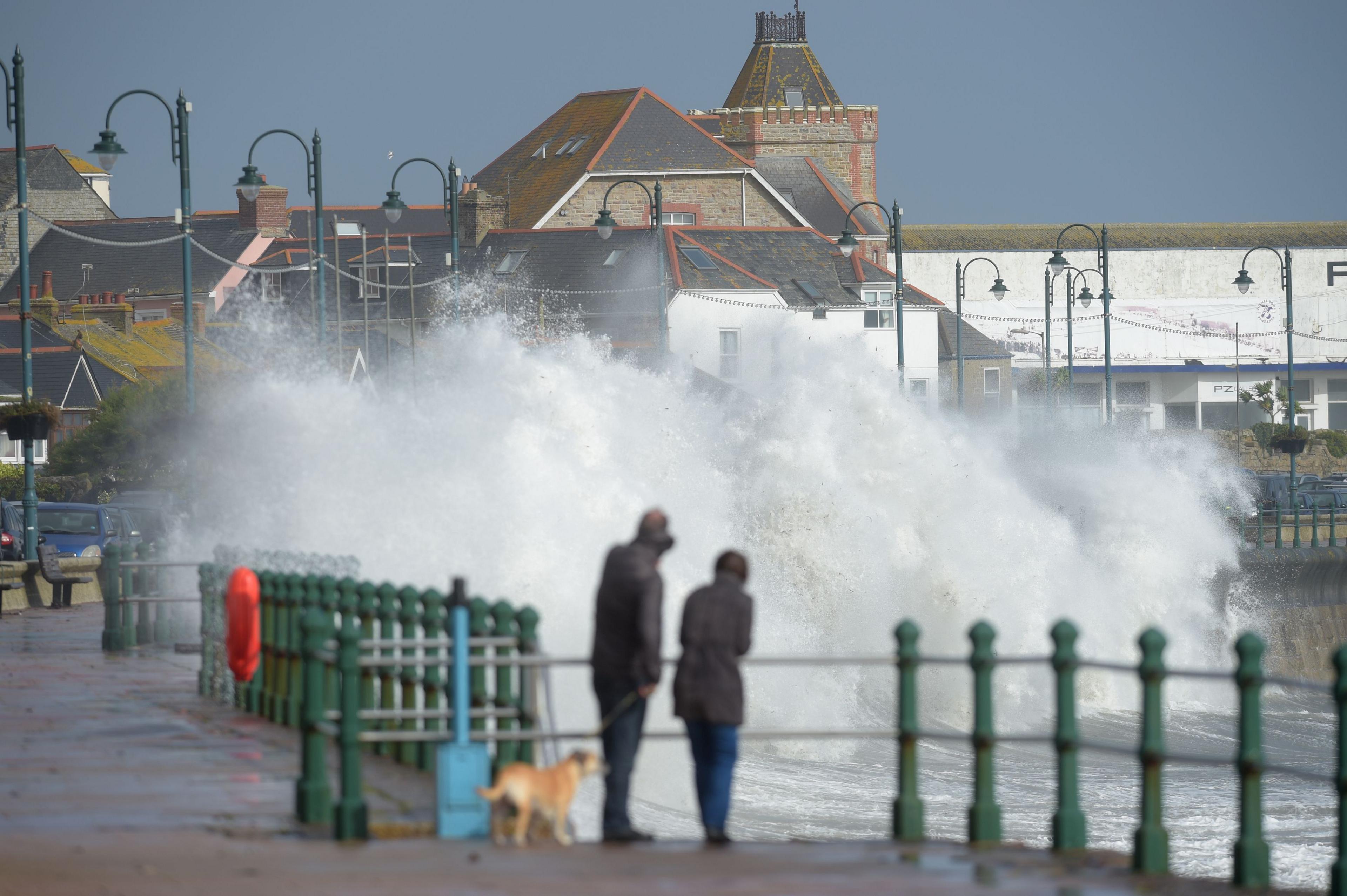 Image source, PA Media
Storm Ophelia in 2017 was one of the most notorious ex-hurricanes to hit the UK
BySarah Keith-Lucas
Lead Weather Presenter
Two large storms in close proximity are churning away in the western Atlantic and the remnants of both may travel eastwards to bring wet and windy weather to northwest Europe in the coming week or two.
Hurricane Humberto - the third hurricane of this year's Atlantic storm season - is currently lying to the south of Bermuda and has strengthened over recent days to become a major category 4 hurricane.
Following unusually close behind Humberto, a second tropical storm - Imelda - has formed, which is also forecast to strengthen into a hurricane as it moves to the north of the Bahamas.
The impacts from these twin hurricanes are bringing a threat of large waves, heavy rain and rip currents to portions of the the US east coast, the Bahamas and Bermuda before they head eastwards later in the week.
Headed for Bermuda
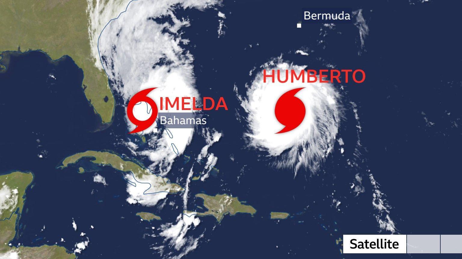
Storms Imelda and Humberto are only around 310 miles (500km) apart, off the southeast coast of the USA
Both storms are forecast to move roughly northwards for the next 24 hours or so, before taking sharp turns to the east and then accelerating across the Atlantic.
Bermuda will experience the largest impacts from both storm systems. Humberto will pass around 90miles (145km) to the north late on Tuesday, whilst Imelda is forecast to move within 25 miles (40km) of the island and has the potential to make a direct landfall by Thursday. Damaging winds, heavy rain and large swells will be the main hazards here.
Whilst Bermuda is well accustomed to the impacts of hurricanes, a direct landfall on the island is rare. However, the last hurricane to hit Bermuda was Hurricane Ernesto just over a year ago in August 2024.
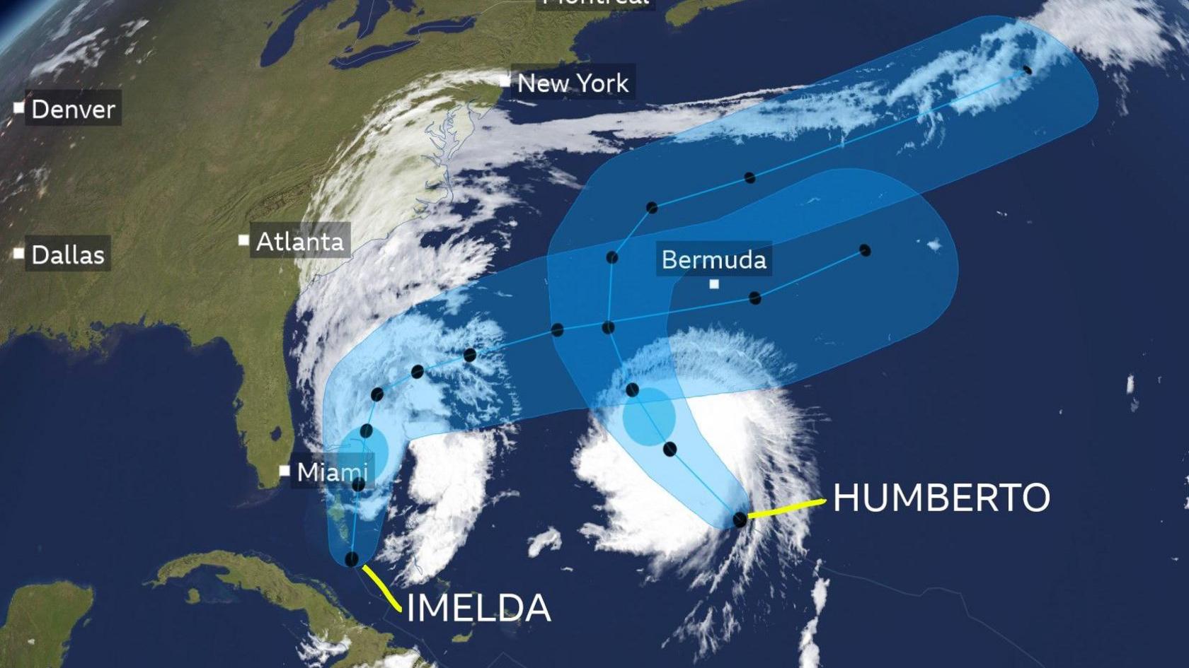
Humberto and Imelda will both track close to Bermuda then north-eastwards across the Atlantic
Portions of the Bahamas and the east coast of Florida and Georgia are also likely to experience large swells, life-threatening surf and dangerous rip currents from Humberto and Imelda on Monday. These conditions will then spread north into the Carolinas and towards the Mid-Atlantic coast through this week.
From midweek onwards, as the storms both drift further out into the Atlantic, they may get swept up by the jet stream and pushed north-eastwards towards the UK and north-west Europe.
Will we get a named UK storm this weekend?
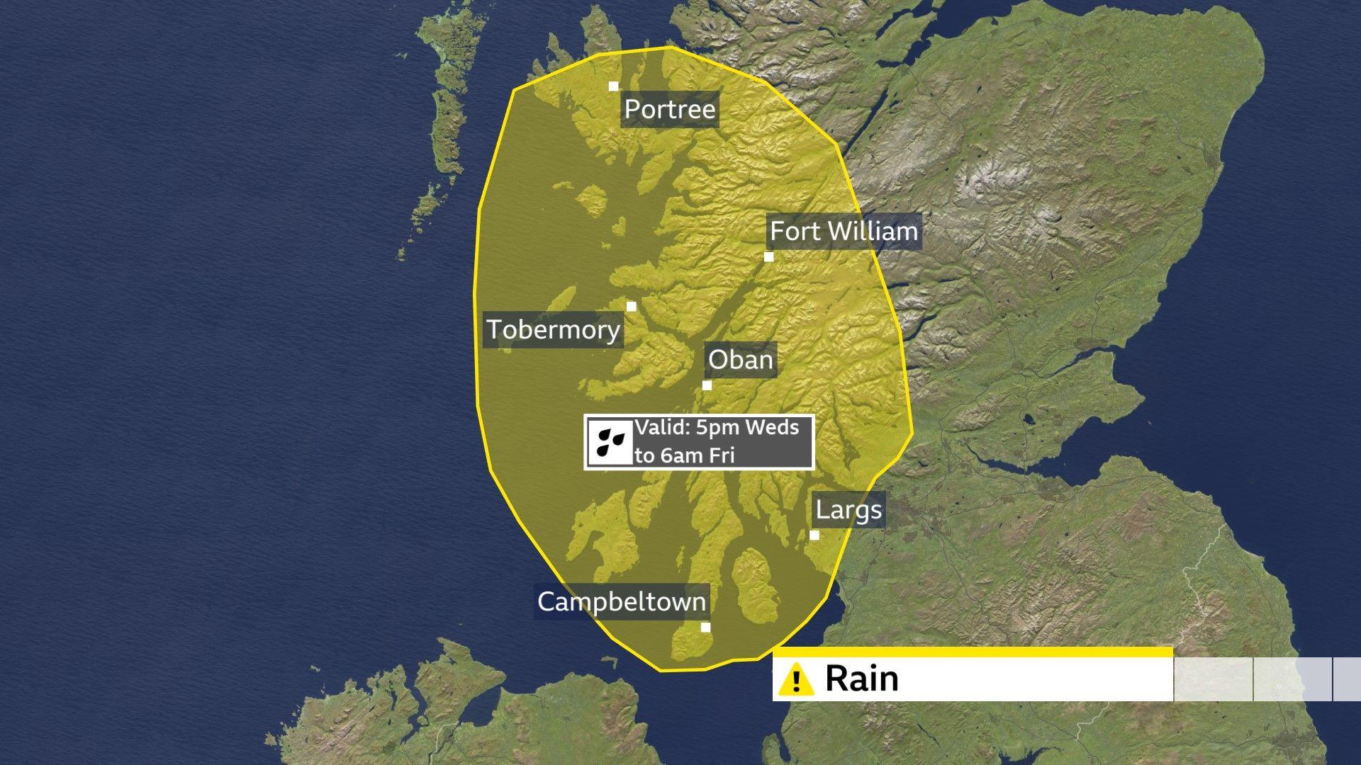
A change in weather type later this week brings the threat of heavy rain to western Scotland before the possible arrival of Humberto's remnants by the weekend
Whilst Humberto will no longer be a hurricane by the end of the week, it does have the potential to bring some disruptive weather to the UK.
Before the remnants of Humberto arrive, the weather is set to turn more unsettled from midweek onwards, with frontal systems approaching from the north-west. The Met Office have issued a yellow rain warning for parts of western Scotland from 17:00 Wednesday until 06:00 Friday.
As we head into the weekend, the rain is likely to become heavier and more widespread as the remnants of Hurricane Humberto push in. Strong winds and large waves are likely, which could lead to further weather warnings being issued.
Tropical Storm Imelda will remain further out at sea for at least the next week and it is unclear whether it will eventually follow a similar path to Humberto towards the UK.
At this stage, the details remain uncertain, and one hurricane can notoriously affect the confidence of weather forecasts, let alone two of them in such close proximity.
It is too soon to say whether we'll see the first named storm of the season, but keep tuned to the forecast by checking the BBC Weather website or App.
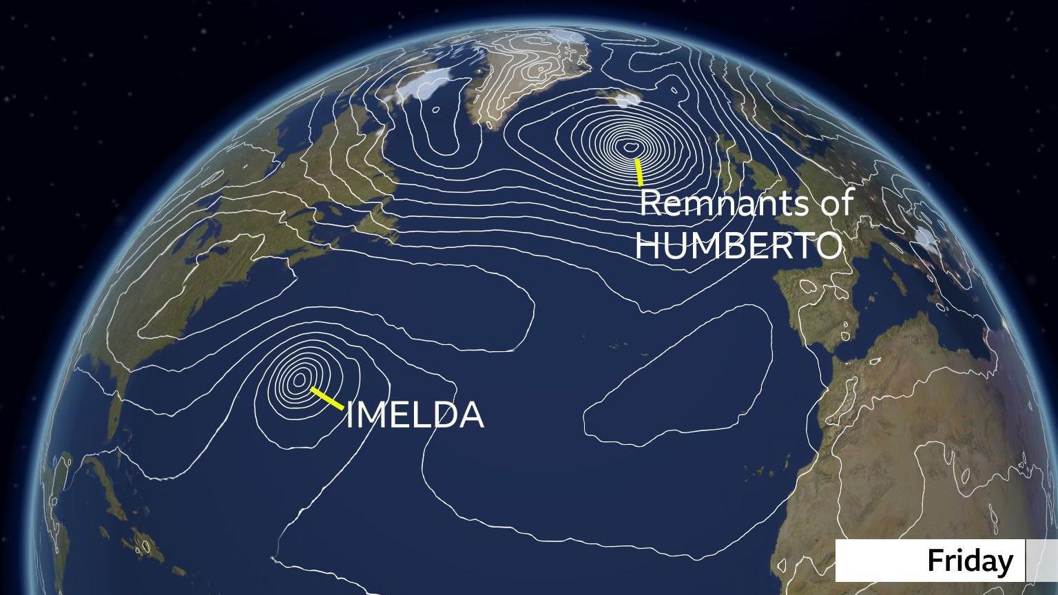
By Friday the remnants of Humberto are likely to sit to the north-west of the UK whilst Imelda remains a hurricane in the mid-Atlantic
Will the storms combine?
When two storms develop in such close proximity, they have the potential to have a big influence on each other's track and potential strength. It is a a process called the 'Fujiwhara effect', external, named after Sakuhei Fujiwhara, the Japanese meteorologist who first described it.
When storms are within around 870miles (1400km) of each other, they can start to interact in several possible ways.
Firstly the storms may orbit each other, rotating around a shared central point, rather like two spinning dancers holding hands in the middle.
Secondly, the storms may merge into one larger system, the stronger storm 'sucking in' the smaller storm.
Alternatively, the storms deflect each other, altering their expected paths and keeping away from each other like two repelling magnets.
The most likely outcome with Humberto and Imelda is that whilst Humberto moves eastwards faster, some of its residual energy and moisture will get incorporated into storm Imelda.