A polar vortex and a red-hot blob: Why Sydney just copped a month’s worth of rain
Severe storms have unleashed tornadoes and hail across parts of NSW and dumped more than a month’s worth of rain in one day on Sydney in a deluge that trapped commuters and sparked flood rescues in the city.
The massive rainfall event during what is usually NSW’s driest month was summoned by a low-pressure system fed by an abnormally warm Tasman Sea, which has stewed at temperatures 2 degrees above average for months.
The polar vortex spiralling over Antarctica is also rapidly weakening, an atmospheric factor which can send more rain-bearing lows and cold fronts charging over Australia, according to forecaster Weatherzone.

Passengers were trapped on the light rail in Randwick on Wednesday night.Credit: NSW SES
The intense low-pressure system off NSW sent 90km/h winds barrelling for the coast on Wednesday and into the early hours of Thursday, causing flash floods which trapped three bushwalkers in Wattamolla and flooded parts of the city on Wednesday night.
Sydney copped more than 122 millimetres of rain between 9am on Wednesday and 6am on Thursday, smashing the monthly average of 68.1 millimetres expected at Observatory Hill. That’s Sydney’s wettest September day in 146 years.
Workers were filmed saving large fish stranded on a road in Bexley by scooping them into traffic cones, while others posted footage of city streets and alleys transformed into raging torrents.
The State Emergency Service made 15 flood rescues in the city from Maroubra to Surry Hills, while flooding in Randwick swamped the light rail, trapping passengers on board. Commuters posted video of floodwater gushing into a bus on the 333 route from Bondi to Circular Quay.
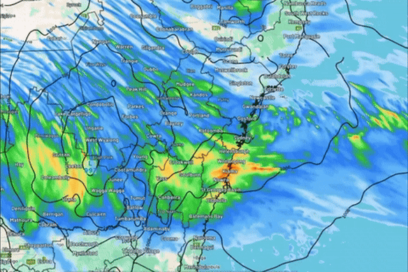
A low-pressure system rapidly intensifying off Sydney’s coastline in the early hours of Thursday.Credit: Weatherzone
There were 854 calls to the SES all up with 34 flood rescues and storm incidents across the Illawarra, Mid North Coast, South Coast and the Hunter.
Forecasters warned at the start of spring we’d be in for a wet few months due to a confluence of factors, including record ocean heat off the coast.
Climate scientist at the University of NSW Professor Matthew England said water in the Tasman Sea had been 2 degrees above average. The warm seas feed moisture into the low-pressure system currently spiralling off the coast.
“On top of this, we’ve had onshore easterly winds most days, which is highly unusual for winter, when we normally see prevailing westerlies,” England said.
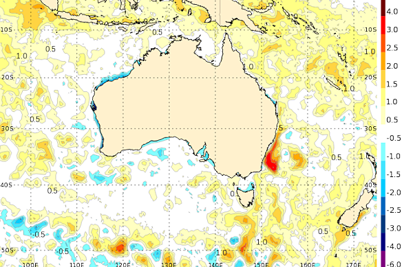
The latest sea surface temperature map from the Bureau of Meteorology shows a hot blob of ocean water sitting off NSW.Credit: Bureau of Meteorology
“These easterly winds pick up moisture from the ocean, which favours increased coastal rains along NSW. So it’s this combination of record ocean temperatures and prevailing onshore easterlies that has likely led to the record-breaking rains.”
The Indian Ocean Dipole is also tracking towards a negative phase, which can boost rainfall to Australia’s south-east.
Earlier this week, Weatherzone flagged that the Southern Hemisphere’s polar vortex was weakening, which increases the chance of cold fronts and low-pressure systems sweeping over Australia.
The polar vortex is a massive region of cold rotating winds over Antarctica. When the vortex is strong, cold polar winds move southward, pulling cold fronts and lows away from Australia.
“By contrast, a weakened tropospheric polar vortex can allow cold air and powerful winds to spread further away from the polar region,” Weatherzone’s Ben Domensino said.
“This can cause cold fronts and low-pressure systems to push further north and become stronger and more frequent over Australia.”
The heavy rains lashing coastal NSW are expected to ease into Thursday.
Start the day with a summary of the day’s most important and interesting stories, analysis and insights. Sign up for our Morning Edition newsletter.
Most Viewed in National
Loading