After a morning of blue skies, residents across south-east Queensland are preparing for an extreme shift in conditions, with forecasters warning severe thunderstorms are on the way.
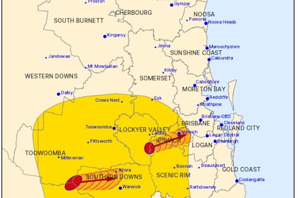
The Bureau of Meteorology issued an alert at midday on Saturday warning of widespread hazardous weather and severe thunderstorms across parts of Queensland from about 1pm this afternoon.
Areas at risk include the Gold Coast, Brisbane, Sunshine Coast, the Wide Bay and Burnett region, Darling Downs and Warwick.
BoM has issued a severe thunderstorm warning on Saturday.Credit: Bureau of Meteorology
Meteorologist Angus Hines said the severe storms could bring “a whole array of weather hazards, including heavy to intense rainfall that can bring flash flooding, damaging destructive wind gusts and large to giant size hail”.
“When it comes to the wind, there is even an outside chance that we could see a tornado or two touch down with the most intense, most severe thunderstorm cells later on today,” Hines said.
The Bureau warned residents to be alert to potential strong winds, with the strength to bring down branches and entire trees.

Severe thunderstorms are expected to hit Brisbane and parts of the south east on Saturday afternoon.Credit: Ben Sartor
“Those trees, of course, can fall onto cars, fall onto houses, and cause significant damage to property,” Hines said.
“We can also see dangerous travel conditions, flooded roads, and possible isolation of streets and locations if that heavy rain does close several roads.”
Hines said regions were preparing to see added stress on the power network, with a strong chance for power outages due to damaging winds and large hail.
Loading
“We absolutely could see more large or giant hail today of five to eight centimetres,” he said.
The threat of another severe weather event has been brewing all week, following a destructive storm that struck parts of south-east Queensland last Sunday, leaving thousands without power and bringing down trees and powerlines.
Hines said today’s storm could continue into the night and, potentially, the early hours of Sunday morning in some areas.
The risk of rain and storm activity will remain for the rest of the weekend, but is not predicted to be as severe as today.
Loading
“It is going to be a very active weekend when it comes to thunderstorms, but today, Saturday, is the key day with the extensive, potentially severe outbreak and high-end hazardous weather.”
Start the day with a summary of the day’s most important and interesting stories, analysis and insights. Sign up for our Morning Edition newsletter.
Most Viewed in National
Loading