Downpours will lash Sydney and NSW from Wednesday as a cold air mass from the Southern Ocean summons single-digit “feels like” temperatures and showers ahead of a predicted low-pressure system off the coast expected to drown out the weekend.
Sydney is set for up to 35 millimetres of rain on Wednesday and up to 100 millimetres between Friday and Sunday, with the heaviest falls expected on Saturday.

A wet Wednesday morning will give way to heavier falls this weekend.Credit: Sam Mooy
“Showers will continue to move across central NSW today, and at the same time, southerly winds are going to start pushing cloud and further showers onto the coast, so this will result in widespread areas of rain around central and eastern NSW, including for Sydney, the Hunter and the Illawarra,” Christie Johnson from the Bureau of Meteorology said.
“There’s even the risk of some thunderstorms along the coast or fringe.”
Johnson said it will be a cold, overcast, wet day for Sydney, Wollongong and Newcastle, with air temperatures of 15 degrees and southerly winds slashing the “feels like” temperature to less than 10 degrees.
The heaviest rain will lash the coast with 10 to 30 millimetres over the next few days before another rain-making weather system intensifies off the coast.
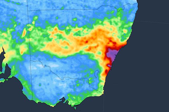
A seven-day accumulated rainfall forecast released by Weatherzone earlier this week.Credit: Weatherzone
“A low-pressure system is forecast to develop off the northern NSW coast on Saturday and rapidly deepen,” Johnson said.
“This low is likely to push rain, possible damaging winds and large waves onto the central and southern NSW coast, with showers also extending over the Northern Tablelands and even up into the Darling Downs.”
On Tuesday, forecast service Weatherzone flagged the prospect of a negative Indian Ocean Dipole (IOD), a climate driver that influences Australian weather similarly to the La Niña and El Niño cycles.
A negative IOD means warmer water stews in the oceans off Indonesia, which increases the chance of above-average rainfall in Australia as well as colder, cloudier days in the south-east.
The index measures the temperature difference in the western and eastern Indian Ocean. A difference exceeding -0.4 degrees indicates a possible negative IOD, although that value has to be maintained for eight weeks for the IOD to be formally declared.
It’s too early to be sure a negative IOD will form, but seven international models predict a negative IOD pattern forming between August and November, according to the bureau.
Sydney research released this week reported that atmospheric warming caused by climate change will increase the frequency of hailstorms by 29 per cent in Canberra and Sydney and 15 per cent in Brisbane, while the largest hailstones could increase by 7.8 millimetres around Melbourne and 3.9 millimetres around Sydney and Canberra.
With every degree the atmosphere warms, it can hold 7 per cent more moisture, creating more turbulent conditions and increasing the likelihood of severe downpours and damaging hail.
Get to the heart of what’s happening with climate change and the environment. Sign up for our fortnightly Environment newsletter.
Most Viewed in National
Loading