By Lloyd Jones
November 22, 2025 — 4.20pm
Top End residents have been urged not to panic but to hunker down in their homes as tropical cyclone Fina approaches and emergency shelters open.
The strengthened category-three system is bringing destructive wind gusts to remote communities in the region after passing over the Cobourg Peninsula overnight into the Van Diemen Gulf.
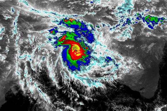
Radar map of tropical cyclone Fina over the Northern Territory.Credit: Bureau of Meteorology
On Saturday, forecasters expect it to track just north of Darwin, which is expected to cop destructive and damaging winds and heavy rain, with the risk of flooding.
Severe Tropical Cyclone Fina will pass just north of Darwin this evening as a Category 3 system. A rapid increase in winds later this afternoon and evening is forecast in Darwin.
NT Police incident controller Kirsten Engels said the situation was serious, but people should not panic.
Everyone should stay in their homes or public shelters until emergency services declare it safe to leave, she said.
Emergency shelters had opened in Darwin, nearby Palmerston and adjacent rural areas, with people urged to bring their own bedding and food.
“Don’t panic, enact your plans, we’ve got this,” Superintendent Engels said.
Loading
“We’re prepared and we’re ready and we’re in this together.”
As the wind and rain ramped up in Darwin, palm fronds were being blown to the ground, a tree reportedly fell on a car and some areas experienced power cuts.
A cyclone warning zone was in place for Darwin, the Daly River Mouth to Cape Don, including the Tiwi Islands, Dundee Beach, Milikapiti, Pirlangimpi and Wurrumiyanga.
At 1pm Darwin time, Fina had sustained winds near the centre of 140km/h with wind gusts of up to 195km/h. It was tracking 75km north-northeast of Darwin.
“Very destructive wind gusts are likely about exposed coastal sites northeast of Darwin today, but the risk at Darwin is assessed as low,” the weather bureau said.
The city could still cop destructive and damaging wind gusts.
Heavy rainfall could lead to flash flooding in coastal areas between the Tiwi Islands and Warruwi, extending across the western Top End including Darwin on Saturday and Sunday.
Senior meteorologist Dean Narramore said 150 to 180km/h category three winds would be near the centre of the cyclone, with winds of up to 120km/h in Darwin.
Those wind strengths would be “easily enough to cause property damage and bring down trees and powerlines”, he told ABC News.
Some island locations have copped 200mm of rain in 24 hours and similar falls were expected in the Darwin area.
Mr Narramore said the impacts were highly dependent on the exact track and intensity of Fina.
“If it moves a bit further north, less impacts for Darwin, more impacts for the Tiwi,” he said.
“But if it wobbles a little bit further south this afternoon, we could see more impacts in Darwin.”
Alice Williams, the office co-ordinator for the Tiwi Islands Regional Council at Milikapiti, near the most northerly reach of the territory, told AAP the winds were picking up and some people were a “little bit anxious”.
Sirens were ready to activate, so the community knew the weather was worsening and it was time to shelter, she said.
The community of about 500 had plenty of food, water and fuel and two extra police officers were on hand to assist.
People had moved to public shelters in the council office and primary school on Friday evening, while others chose to stay at homes deemed safe, Ms Williams said.
As the wind and the rain ramped up in Darwin, most businesses were closed, including major supermarkets.
Conditions are set to ease in the Top End by late Sunday as the system moves to Western Australia.
Cyclone Tracy was the most devastating system to hit Darwin, killing 66 people on Christmas Day, 1974.
Most Viewed in National
Loading